Petros Koufopoulos, Diomedes Myrianthefs
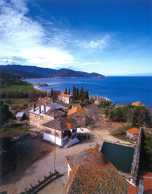
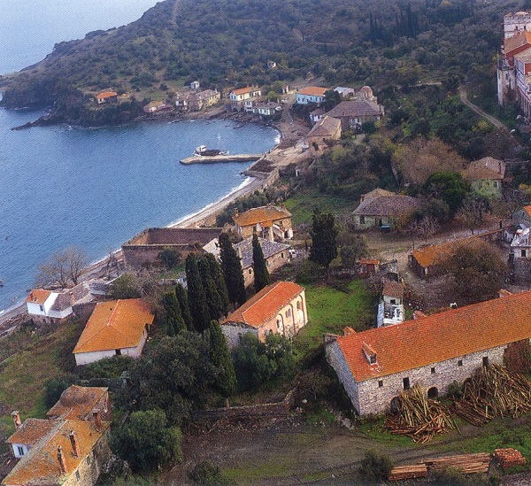
The buildings in the immediate environment of the Vatopaidi Monastery constitute one of the most noteworthy and best-preserved of complexes outside a monastery on Mount Athos. These occupy an extensive area, mostly to the north of the Monastery. From the point of view of the number and size of such buildings, it is second only in importance to the Monastery of St Panteleimon and perhaps the richest in the variety of buildings. Moreover, the workshops of the Mon-astery are in technological terms amongst the most advanced on the Holy Mountain and some of them are striking in their size. This complex was at the highest point of its development in the late 19th century, a time when considerable alterations and extensions were being made to buildings and other installations. Important reasons for their extensive development outside the precinct were the conditions of security which prevailed at that time, their closeness to the Monastery, and its significant degree of economic recovery.
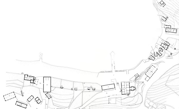
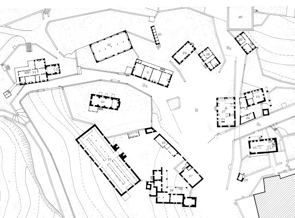
The ancillary buildings, 50 in number, were developed in the immediate vicinity of the Monastery, so that together they formed a single entity. These together with the enclosures of the gardens, the roadways, and the flattened areas produced a cohesive complex of an urban type, comparable with that of traditional settlements.
For the purposes of transport and communication, a system of cobbled roads and approaches was created. The road leading to Karyes (A1) was the basic link with the hinterland of the Holy Mountain. This ends at the flat space to the west of the Monastery (A) and in the piazza of the gatehouse, with its typical, circular, stone paving.
From the southern edge of this space another cobblestone road sets out (A1). This leads to the Skete of St Demetrius. Lower down, and continuing the flat space in front of the gate (A), a second piazza was created (B), from which the basic roads (B1 and B2) leading to the two jetties (C1, D1) and the buildings on the seashore start. The first of the jetties must occupy the same position as it did in Byzantine times, while the second seems to have been built in the last decade of the 19th century. The first of the roads (B1,) rests upon a strong and high retaining wall and crosses over road B2 by means of a vaulted bridge.
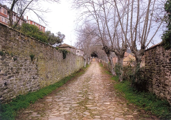
Its construction seems to have been completed a little before 1870. Two other vaulted bridges were built to the east of it. The supply channel for water to turn the mills passes under the first of these, and the central channel for the irrigation of the gardens down by the shore under the second. A third cobbled road (B3) spirals downhill from the western edge of platform B to the gardens to the west of the Monastery.
The buildings in the immediate environment of the Monastery are laid out in three distinct units. The first is that by the seashore (buildings 1- 21), the second that of the lower piazza (B), around the perimeter of which buildings 22-39 stand, while the third includes a very few buildings to the south-east of the Monastery (41-43).
The buildings in the first group are laid out in a linear manner along the seashore, covering a length of more than 400 metres.
They are dominated, in the middle, by the great arsanas of the Monastery (13), perhaps the oldest building outside the Monastery’s walls.
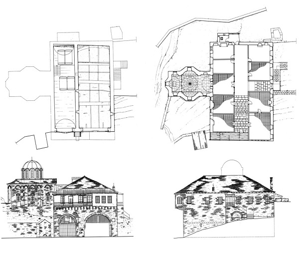
The western landing stage (arsanas) was built in 1496 by the voivode Stefan, as can be seen from the relief inscription on stone on its facade.
The eastern vaulted arsanas, the Chapel of St Nicholas on the eastern side of the building, which bears the date 1872, and the floor above the two arsanades make up a single building phase.
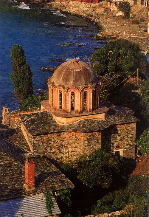
The chapel is of the compact cross-in-square type with choirs and a cupola on a high drum. The veranda and the covered balcony are borne on a row of imposing successive wooden beams which protrude from the line of the wall.

To the north-east of the great arsanas lies the area of the ‘private’ arsanades (2, 3, 5-10).
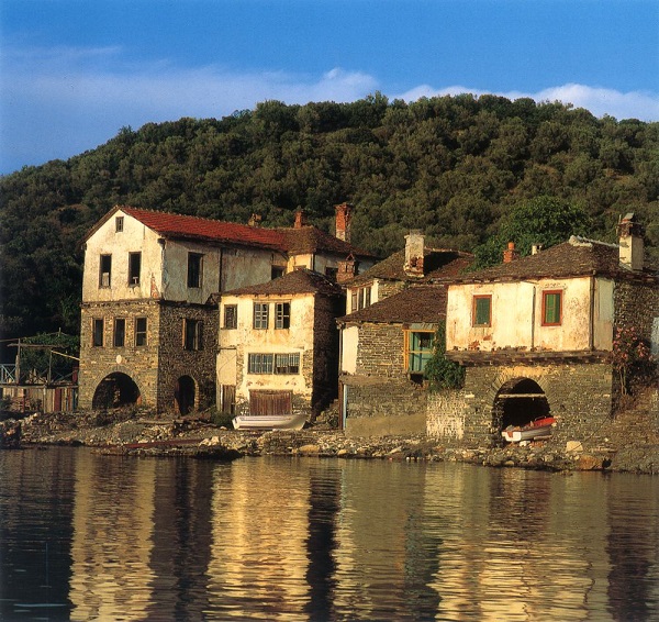
These arsanades made their first appearance in all probability in the late 17th century. They are two-storeyed with a mezzanine or three-storeyed and follow the typical arrangement of having an area for the safekeeping and maintenance of the boat on the ground floor, the place for the keeping of nets and fishing equipment on the first floor or mezzanine, and the living quarters on the top floor. As can be seen from the old photographs of 1879 and 1883 , on the southernmost edge of the area of private arsanades there was a large three-storey arsanas, which was probably demolished at the end of the 19th century. The same photographs show that each arsanas had its own stone pier. In certain cases these had a wooden extension and wooden posts for the tying up of the boats and the spreading of nets. Later, the masonry piers were replaced with shorter wooden ones.
In among the complex of arsanades there are three workmen’s houses. The first is to the east of the great arsanas and bears a date of construction of 1872 (12). The second, further north, a building of large dimensions, has a stable on the ground floor and accommodation for workmen on the floor above (4). In all probability it dates from the early 19th century. The third is at the northernmost point of the complex of buildings on the seashore (1) and it seems that it housed the gendarmerie. The ground floor has been laid out as detention cells. It must have been built in the early 20th century.
Higher up from the seashore, on a small hill, are the Monastery’s carpenter’s shop and drying plant (11), also a building of the late 19th century, which takes the shape of a large wooden shed with masonry piers around its perimeter.
Near the great arsanas and at the point where the cobbled road from the Monastery to the shore (B1) ends, there is a fountain (14), which has on it a plaque with incised decoration, and inscription, and the date 174[0]. This fountain is one of the oldest constructions on the shore, and is described by Barskij. It appears from old depictions of it that it once had a wooden shelter over it.
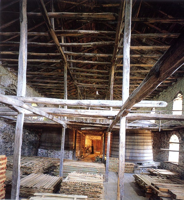
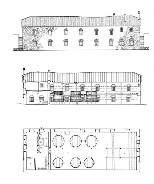
On the other side of the road is the three-storey building of the wheat barn (15), which stands on the shore, near to the jetty for ease of access. Barskij, in describing the area outside the Monastery, refers to the existence of an older barn to the east of the cemetery, on the shore, which probably stood on the same site. The present three-storey building is of particular note and is the second largest building for the storing of wheat on the Holy Mountain, after that of the St Panteleimon Monastery.

The ground floor and the first floor were built in 1820, and the second floor in 1899. The three levels of the building do not communicate with one another. The lower of these is roofed with a semi-cylindrical vault, reinforced with four curved braces, while the one above and the roof are of wood.
To the west and side by side with the wheat barn there are four ‘private’ gardens (16-19). They are surrounded by high walls and can be approached either from the seashore, or from the south by means of masonry steps in the retaining wall. Within their precincts there are small two-storey or three-storey houses and installations for irrigation (cisterns, channels, etc.). These houses were used by the fathers as temporary residences, and for the storing of argricultural produce and the harvest. They date from the late 19th and early 20th century.It would seem that the high wall on the north along the shore was already there in the late 18th century and is shown in the well-known copper engraving of 1792, in which the garden is represented as an undivided bitter-orange orchard.
In 1903 the two-storey building of the hay barn (20), of striking size, was built immediately to the west of the gardens. It was in use until 1911, when it was burnt down and abandoned. It is at this point that the second of the cobblestone roads (B2), which starts out from the gate of the Monastery and goes to the seashore and the second jetty, ends.
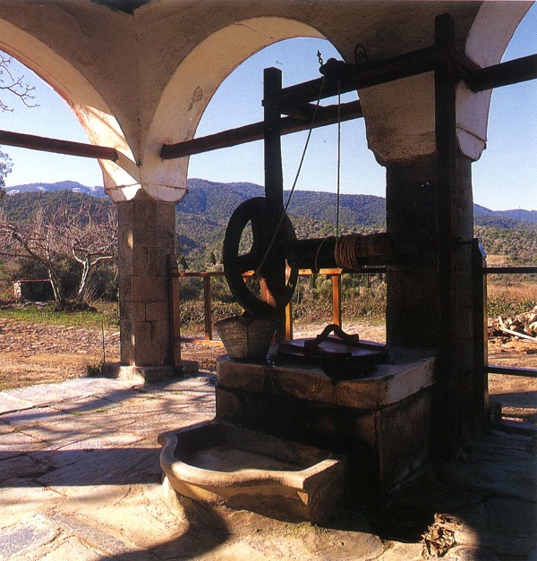
At the westernmost point of the seashore area is the Monastery’s oil press (21), a building dating from the third quarter of the 19th century. From Byzantine times down to the 18th century the oil press was inside the Monastery’s precinct. The current oil press complex consists of three parts: the main workshop, together with two-storey living quarters at its north-western corner, the water power system – which includes the vertical vane and the water courses – and the area to the east where the olives are brought after they are harvested. The equipment of the workshop includes the mill, with a pair of cylindrical stones, a pump, a hydraulic press, and a system of axles and belts to operate them, as well as a masonry tank for the separation of the oil from the water.
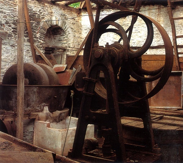
The power was supplied by water until the 1930s, when a diesel engine was installed. The olive press was one of the largest and technologically most advanced on the Holy Mountain.
Lining the eastern side of the B2 cobbled road are a workmen’s house (22) near the hay barn, which bears an inscription with the date 1847, and the two mills of the Monastery (23, 25). The mills were driven by a system of water courses and vanes. At the ‘lower’ mill (23), the mill-race was provided with the help of an elevated reservoir. The ‘lower’ mill dates from the early part of the 19th century, while the upper floor was added at its end. The ‘upper’ mill has an inscription with the date 1869, and still has inside it extremely interesting equipment and machinery for driving, by means of a horizontal and vertical vane, two separate pairs of millstones.
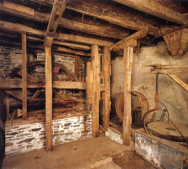
As we know from Barskij, in the mid 18th century there were two mills outside the Monastery, close to the gate and the nearby cistern, which, as is clear from his description, were driven by water. In an engraving of the Monastery of 1792, two similar buildings are shown on the same site, one of which is described as a mill. It seems likely that the ground floor of the ‘lower’ mill dates from the time of Barskij (1744), while the ‘upper’ mill was built on the site of the second mill which Barskij saw in the course of his visit.
It seems that the mill or mills were among the first buildings to be removed to outside the Monastery, with a view to exploiting water power for their operation.
Near the ‘lower’ mill and adjoining the retaining wall of paved road B1 is the single-roomed, simply constructed building which housed the Monastery’s tinning shop. This is a building which dates from early in the present century, perhaps unique on the Holy Mountain in that its only function was tinning.
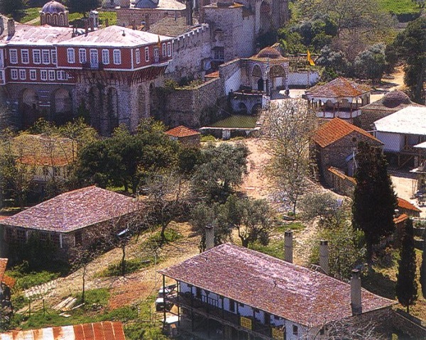
The second group of buildings outside the Monastery occupies the area at its north-western extremity and is marked by the arrangement of the buildings around the large stone paved flattened space B.
To the east of this space and at the point where roads B1 and B2 meet is the blacksmith’s – coppersmith’s shop (27) (1884). This is a simple single-storeyed, single-roomed construction, with a wealth of equipment, which was in use until the 1960s. It is the second largest metalwork shop on the Holy Mountain, after that of the Russian Monastery of St Panteleimon. As can be seen from the photograph of 1871 and the engraving of 1879, the earlier blacksmith’s shop, smaller than the present one, occupied the same site. Immediately to the north is a workmen’s house (28), built in the early 19th century.
The layout of the premises on the ground floor, where there is a hearth in the middle and a charcoal store, suggests that originally this also housed a coppersmith’s shop. Next to it is a single-storey ancillary building (29) of the late 19th century, which originally had two floors with a covered balcony linking it with the upper floor of the neighbouring coppersmith’s shop. On the north-western edge of the stone paved area is a large workmen’s house (31), the first building phase of which dates from the mid 19th century. Its upper storey seems to have been an addition of the later part of the same century. Today the building is used to provide accommodation for the police and the port authority, which have a post at Vatopaidi. From the north-west of the paved area the third cobbled road (B3) leads to the gardens of the Monastery to the west. On the north side of the road are the second hay barn of the Monastery (32), built in the late 19th century, and the Kathisma* of St Tryphon of 1882. The church belongs to the same phase of building as the accommodation, which is of two storeys, with storage space on the ground floor and the living quarters and church on the second. It has a covered balcony on the north and west sides, borne on a line of piers. The lavatory building is a separate construction, linked with the main building by a wooden bridge.
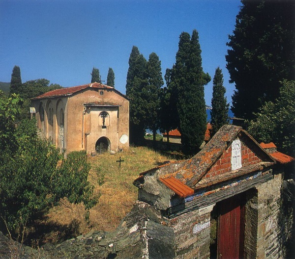
On the western side of the paved area is the cemetery and the cemetery chapel (34), fenced in by a high wall of 1892.

Until the 16th century the cemetery was within the precinct of the Monastery, to the east of the katholikon. The exact date of the present cemetery chapel, dedicated to the Holy Apostles, is not known.On the ground floor, below the church, is the vaulted ossuary, which seems to be oldest phase of the building. We hear of a restoration of the chapel in 1683, and the wall-painting most probably belongs to the same period. A narthex was added in 1841. In 1945 the chapel was burnt down, as was the sexton’s house adjoining it. The chapel is entered from the south and it is covered by a semi-cylindrical vault and a pitched roof with truncated gables on the narrow sides. The external facades are made up of blind arches, and the apse of the sanctuary is three-sided.
Immediately to the south and adjoining the cemetery wall is the ‘vordonareio’ (stabling) (35) – of impressive dimensions – and other small ancillary buildings (36). The vordonareio dates from the middle of the 19th century, and is of two storeys: the upper one for the stabling of the mules and the lower for the collection of manure. Provision was made for the building of a further storey, but this was never carried out.
Immediately next-door to the vordonareio is the two-storey kathisma* dedicated to St Modestus (38) – also known as ‘hatoulario’. It is of an ‘L’ shaped plan, with its church attached to its south-eastern corner. The building, together with its church, seems to date from 1848. The addition of a kitchen, lavatory building and staircase on the west must have taken place in the late 19th century. The ground floor housed the old stable and hay barn of the Monastery, while the first floor was accommodation for workmen. The building has a wide covered balcony, supported on a row of piers, on its north and west sides, by means of which the church and the rooms on the upper floor are reached.
The nearby electric powerhouse (37) is a building of 1914,still in use today. Vatopaidi was the first monastery on Mount Athos to install such a powerhouse, and it is one of the oldest in Macedonia.
On the northern edge of the paved area in front of the gate (A), near the gate itself, is the ‘kiosk’ (39). This was already here in the time of Barskij, was renovated in 1780, and is mentioned by Uspenskij. A building with a solid masonry base on the ground floor, which provides storage space, it is an open construction above, providing a place to rest and enjoy the view. In 1960 its upper level was completely reconstructed and its wooden bearing structure was replaced with reinforced concrete. At a distance of about 100 metres to the south is a well-house (40), which bears a date of construction of 1877.
This replaced an older well-house, of a similar form, which Uspenskij mentions. This too is an open wooden construction, housing the well and providing a sheltered place to rest upon the way.
The third group of buildings outside the Monastery lies to its south-east. At the top of a small hill is the large cistern (43), intended to be used for extinguishing fires when it was constructed in 1901. It is made out of stone and is plastered on the inside with a strong compound of powdered brick; it is roofed by vaulting which is borne on piers. It is filled from the springs of St Onuphrius.
The nearby ‘patitiri’ (vat for treading grapes) and ‘rakario’ (raki distillery) building (42) is particularly impressive. According to the dating above its western entrance, it too was constructed in 190156. The patitiria were inside the Monastery until the end of the 19th century, together with the wine cellar. The choice of their position, on a hill outside the Monastery, was dictated by the need for there to be a difference in height between them and the wine store, thus making it easier to channel the grape juice to it by means of an underground system of piping. The building has two storeys, its ground plan being in the shape of an elongated rectangular parallelogram of a length of some 40 metres. It is divided into two functional units. On the east is the patitiri, which contains six large vats for the crushing and treading of the grapes, of a total capacity of around 200 cubic metres.
The western part of the building has the rakario on the ground floor and a workmen’s house on the floor above. The rakario’s equipment remains complete, and it was brought back into operation recently.
At the southernmost point of this group of buildings is the Kathisma of St Artemius (41). This consisted of a church, with a two-storey building adjoining it on the west, which, however, has not survived.